

Should you mitigate the risk of drones? That depends on a multitude of factors ranging from the airport surroundings, type and number of operations at your airport, to events in the near proximity (i.e. festivals). To put it briefly, we are talking about factors that would increase (or decrease) the risk of aircraft and drones operating in the same airspace. One thing is certain – you should not invest in a drone detection system based on fear. It should be a fact-based informed decision and the mitigation should match the actual risk at your airport.
What is the actual risk of a collision between aircraft and drones at your airport?
Get a drone risk assessment for your airport
Drone Risk Assessment and Mitigation in Airports “DRAMA”
The industry is collaborating
Together with a number of airports and aviation industry risk assessment specialists, AscendXYZ has developed a Drone Risk Assessment Model that can be implemented at your airport. This model enables you to identify and monitor the risk specific to your airport and, if necessary, introduce the most suitable mitigations. The model and its continuous improvement are being developed under the European Space Agency’s Business Application Program.
The Risk Assessment
Objectives:
- Enable airports to identify the risk level for the airport.
- Enable threat level classification per UAS (Unmanned Aircraft System) operation.
- Support standardised approach to risk assessment of UAS activities to identify the risk of a mid-air collision based on interpolation of air safety knowledge, threat- assessment, vulnerability-assessment, and knowledge of the local area.
- Enable ongoing risk assessment.
Preconditions for DRAMA risk assessment:
Basic risk approach is the interrelation of the threat’s probability of occurring and the severity in case it does occur. In statistical scenarios, the value can be entirely mathematically calculated. However, in this model, a qualitative analysis of both variables is necessary, since the empirical data is sparsely quantitative and based on historical data. Therefore, the development of DRAMA model will, in some cases, require an investigative approach to quantify the probability and/or establish the severity. In those cases, the development will require in-depth knowledge of specific technical areas.
Probability factors:
Airport size
Regarding the airport size, what matters is the total number of aircraft operations. This number is quantifiable in terms of take-off’s and landings. However, for the risk assessment, the time of exposure to the UAS threat is more informative when calculated in minutes of operations over a “standard” 24 hours period.
For further analysis it is important to divide the operational minutes into the different phases of the 24 hours.
Airport size summary:
- Total minutes of operations per 24 hours.
- Minutes divided into different phases of 24 hours.
Type of operations
It is important to specify the air traffic activity in the airspace within specific airport-controlled sectors. There is a big difference between commercial approaches and departures (mostly following IFR – Instrument Flight Rules), training flights with multiple take-offs and landings in a VFR (Visual Flight Rules) pattern, VFR overflight points and most commonly used air-routes. Therefore, determining the operational use of the individual runways will also affect the probability of a collision between drone and aircraft (due to the geographical dispersion of traffic).
Data about the approach types needs to be collected to quantify the airplane’s maneuverability in space. This information will determine the airport’s specific areas with greatest vulnerability.
Airport location
In-depth knowledge of the airport location is important when evaluating risk. The surrounding area is divided into the following categories:
- Countryside (sparsely populated, used for agriculture and farming, forests etc.)
- Small towns
- Large cities
- Recreational areas (campsites, lakes etc.)
- Densely crowded areas (Amusement parks, festivals etc.)
- The airports must provide the information about closely located densely populated areas.
The Ascend team will analyze web maps (Google maps or alike) in order to provide data for categories 1. – 4. mentioned above.
UAS activity
Historical data on UAS activity within the defined area of the airport is essential for the calculation and prediction of the most probable risk-level.
- The size of the area will be determined in collaboration with the airport to match local requirements and legislation.
Data must be provided from all available sources, as a minimum:
- Reports from the ground crew, ATC, pilots etc.
- Measurable digitally provided collection of UAS data.
Data needed
The airports must provide the information mentioned in paragraph “UAS Activity” (reports from the ground crew, ATC, pilots etc.). If other relevant data sources are already available in the airport (i.e. RF sensors, radar etc.), AscendXYZ can include that data in the risk assessment. The AscendXYZ can provide a passive UAS detection unit on site. The data from the UAS detection unit will be accessed remotely by AscendXYZ.
- AscendXYZ will specify the data needed in the DRAMA implementation process.
Severity factors:
Aircraft types
The specific aircraft type matters in terms of vulnerability in case of a collision with the UAS. Specific aircraft type’s structural toughness and certification will affect the severity together with the UAS type.
Therefore an overview of the most common aircraft types used in the airport is essential. If used by multiple aircraft types, the severity assessment can be divided into several risk groups.
The airports must provide statistical data on aircraft types operating in the airport. If possible, divided into 24-hour phases mentioned in paragraph “Airport size”.
- AscendXYZ team will analyze the structural vulnerability of different types of aircraft, based on FAA ASSURE study – UAS Airborne collision severity evaluation.
UAS type
The specific UAS type matters in terms of size (structural & weight), maneuvrability and operational criteria’s (endurance, speed, altitude, distance from operator etc.). UAS must be categorized by weight that is the most important factor with direct relation to speed and manoeuvrability, as well as one unmitigable energy factor in case of a collision with an aircraft. According to the EU Commission Regulation (EU) 2019/947 there are 3 categories of UAS operations (Article 3-6): a. ‘open’ category, b. ‘specific’ category c. ‘certified’ category. Additionally, in EU Commission Regulation (EU) 2019/945 requirements for design and manufacture of unmanned aircraft systems (UAS) (ANNEX part1) 4 classes are described (0, 1, 2 and 3). Each class is defined by weight.
The open category (described in EU Commission Regulation (EU) 2019/947 article 4 is presumably the most common category type, due to the requirements and availability for consumers. Therefore, DRAMA risk model will focus on this segment.
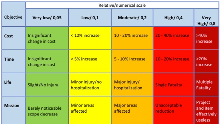
The FAA ASSURE study used the common UAS type DJI Phantom which has a starting weight of approx. 1,2 kg and a fixed-wing UAS with a starting weight of 1,8 kg, both in the C1 class. The study showed significantly critical damage to the selected aircraft types. Therefore, for this risk model class C1 and above will be treated as critical threats. Unless mitigation actions are taken, the risk model will, as a default, define collisions as highly critical, with high/very high severity level in one or more of the objectives (see the scheme above in paragraph “Aircraft types”).
Airport-specific discussion
Most risk models are using a scalable definition of the probability of an unwanted event occurring. See the example:
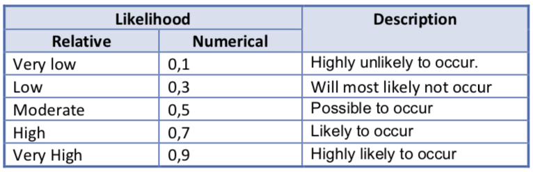
In this case, the problem is to define a suitable risk probability of an aircraft and UAS collision, if they happen to be in defined airspace at the same time. It is impossible to predict this probability since most UAS’s operate as autonomous systems (UAS and operator) and at the same time, the aircraft will alter from a predetermined course if they spot the UAS or are on a VFR approach. There are simply too many unknown variables.
Therefore, it is practical and more suitable for the professional risk assessment, that the DRAMA risk model will determine the worst-case scenario and assume that a UAS and an aircraft in a defined area (airspace) will collide. This will, of course, affect the availability of mitigations towards the scenario in which the two objects are in/approaching the same area.
Financial risk assessment:
Disturbance to the air traffic due to drone operations can result in significant delays. Therefore, the financial implications for the stakeholders (the airport, airlines, passengers, and other related businesses) should be analysed and quantified. Depending on the airport size and use it might be operating at 99% or 1% capacity. Thus the effect of disturbance to the safe uninterrupted execution of air traffic and subsequent financial impact will also wary significantly from airport to airport.
Essentially, there are two important drivers for solving this problem:
- If it is a risk to flight safety
- If it is a significant financial risk
It might be both at the same time. However, for some airports, the actual flight safety risk might be low, but the financial risk might be unacceptably high.
Based on the above-described DRAMA model AscendXYZ can, in collaboration with the individual airports, calculate the potential financial impact of disturbance to the air traffic at your airport, giving you a per-minute downtime cost.
Continuous risk monitoring
The risk assessment output is not static. Therefore we recommend that the risk is continuously monitored in order to identify changes in the risk level and adapt mitigations accordingly. After the implementation of the DRAMA model airports can perform and update the risk assessment in-house or employ AscendXYZ to reevaluate the risk at set intervals.
Other Ascend services and products


